SkyWire Video and GPS Integration
Skywire Video is committed to integrating GPS or Location Information with Video at a number or levels. This integration extends to location information from not only GPS but from Cell Phones and 802.11 networks. The concept of "location" is abstract so any future location formats can readily be integrated with the system.
- Motion Detection used for Tracking and Targeting
- Video Capture that can be used with Aerial Filming
- Virtual GPS MPEG Channel Location Tracking
-
GPS Overlay Integration
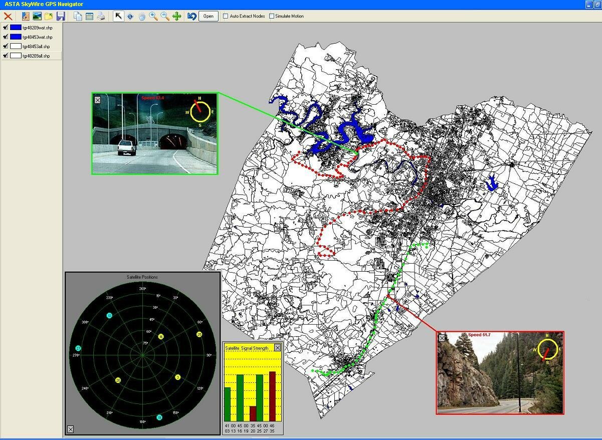
ScreenShot of SkyWire Video GPS Tracker Client
Motion Detection used for Tracking and Targeting
Motion Detection has been a valuable enhancement to security systems for many years. Using a variety of sensors, security systems have been able to detect moving objects, and then take actions including:
- Sounding an alarm
- Recording video of the object that triggered the alarm.
New digital technology has added more capability to motion detection in security systems. Now motion can be detected wthout the use of external sensors, by analyzing the pixel content of images. New actions can be taken when motion is detected, including sending e-mail alerts based on motion detected.
ASTA Technology group has now taken motion detection to a new level, by integration Latitude/Longitude reporting into motion detection. This allows a software-based motion detection system to not only report that an object has been detected, but also to report the exact latitude and longitude of the detected object, with accuracy equal to a good GPS system.
It can also be integrated with a variety of other applications, including:
- Mapping software
- Statistical analysis software
- Targeting systems
Video-based motion detection works by evaluating changes in pixels. The SkyWiretm GPS Image Tranlsation Utility maps pixels to Latitude and Longitude, with the accuracy of a good GPS system. It associates each pixel in the image with Latitude/Longitude coordinates. p>Once an image is "calibrated", the Lat/Lon coordinates of each pixel are stored in an array. When motion is detected, the software knows the X,Y coordinates of the pixels that triggered the motion detection. Those X,Y coordinates are already associated with Lat/Lon coordinates. The Lat/Lon coordinates of those pixels are reported along with the alert. System overhead is very low, because no computation is required when motion is detected. The coordinates for each pixel are already stored in an array, and are simply retreived for reporting.
Modern GPS units can report Lat/Lon coordinates to within a few meters. The SkyWiretm GPS Image Tranlsation Utility can bring this same precision to its Lat/Lon reporting.
Basically, an image is "calibrated" by entering the known coordinates of the corners of a quadrangle (of any shape) in the image.
The system then uses sophisticated algorithms to convert the vertical plane of the image, to the horizontal plane of the area being monitored. It then associates each pixel in the image with appropriate Lat/Lon coordinates. So the system is as accurate as the GPS coordinates used to calibrate the image.
Video Capture that can be used with Aerial Filming
When Video is captured from Video Boards, Web Cams or HTTP Cameras, SkyWire Video can optionally record the video using MPEG4 and also capture location information.
Location information can be included with the video and timestamp data which allows for playback options that include
- Displaying Location Information
- Displaying Maps Rendered by the Server along side the Video On Playback
Virtual GPS MPEG Channel Location Tracking
SkyWire announces our new patent pending technology that creates a Virtual GPS channel available via MPEG4, H263 or JPEG video codecs.
Client devices can use a variety of GPS devices and location information is transmitted to remote SkyWire Video GPS servers that save the information. Users and Groups can be defined with administrative setup functions so that real time or archived GPS data can be replayed as "virtual MPEG4 channels".
Skywire Video supports a virtual GPS channel. This allows for clients using GPS (and possibly 802.11 without gps) to send tracking information to Skywire Video Servers.
Other clients can then request location information, in real time, or historical, on any single user or groups of users.On the server, a map is rendered based on the user or groups of users and streamed down in MPEG4 format to Pocket PC and Win32 clients or to Java Phone Clients using the appropriate codec.
This not only allows for real time tracking data to be viewed by managers but also to replay at any time, historical information to see where any user has "been"
Since SkyWire Video supports ARM Linux devices, this technology could be oem'd to router or wireless hub companies to be included in actual equipment. SkyWire Video is also moving to add psos+ support from WindRiver.
GPS or Location Information can be captured on SkyWire Video Clients. These include
- PocketPC Clients
- Win32 Clients
- Cell Phones
- Video and Audio Capture Appliances
|


